

What’s New in Intelligent Vision
Updates and new releases at Unleash live

INTEGRATIONS
Fully Automated Missions with SkyCharge Integration
Unleash live now integrates with SkyCharge, enabling users to launch fully automated missions with their autonomous drone-in-a-box solution. Save time and costs by conducting remote asset inspections without the need of a drone pilot in-field, and reduce the risk of workplace injuries associated with manual inspections.

GEOGRAPHIC CONTEXT
Mission Planner in Atlas
For drone pilots conducting inspection missions, our Unleash.Cloud platform offers a seamless solution. Users can effortlessly upload their missions, efficiently plan and distribute them to pilots for execution and subsequently review the mission in 2D (with 3D capability currently in development). The user experience is also greatly enhanced with the ability to easily add, edit, or remove waypoints.
One of our standout features is the application of smart inspection profiles for new routes, particularly beneficial for large areas or corridors. This functionality enables users to precisely determine the optimal angle for capturing imagery at each utility pole, resulting in repeatable, efficient, and consistently high-quality media from inspections.
Once a mission is completed, in-field pilots can access it within our Autofly software to view the mission with ease.
With large scale automation, users can expect a significant improvement in the quality of data captured, as it eliminates the need for manual flight operations.

UNLEASH.AUTOFLY
Updates to Autofly Software
Unleash.Autofly, the collaboration platform for remote drone operations, has a range of new features including:
A new mission view allowing users to quickly review flight paths, mission information and asset position before execution
A pre-configured button layout for customizable buttons (C1 and C2), allowing faster setup and uniformity between field crews using different hardware
Enhanced precision landing for field and drone dock deployments, enabling safer operations around critical infrastructure
Optimized upload and media sync feature for uploading data directly from the field to your secure unleash live account
Display and manage flight paths at both relative (AGL) and sea level altitudes (ASL) providing simpler deconfliction between crewed and uncrewed aircraft
Import, generate and execute missions around assets in a global coordinate system, ensuring safer and more repeatable inspections of critical assets

AI ANALYSIS
AI Configuration
We've made significant strides in enhancing the user experience and expanding the capabilities of our AI platform for defining object detection zones and configuring AI applications for video streaming.
With the introduction of features like customizable bounding box configuration and bi-directional lines, users now have unprecedented control over their object counting and detection needs.
This translates to increased accuracy and precision tailored to their specific requirements. Moreover, our commitment to user-friendliness ensures that setting up these configurations is a seamless process. These improvements mark a significant step toward self-service AI customization, making our platform highly adaptable, detail-oriented and accessible through its intuitive user interface.
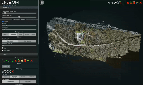
2D & 3D MODELLING
Generate models of your assets
Unleash live's capabilities extend beyond the realm of video analytics. By capturing extensive high-quality imagery and synthesizing it with LASer data, Unleash live was able to generate comprehensive 3D Point Cloud models of assets such as pipeline and power line corridors in our GIS (Geographic Information System).
These 3D models serve a variety of crucial use cases, such as identifying right-of-way issues, where vegetation encroachment on assets is a concern. Additionally, these models prove invaluable for strategic planning, aiding in the visualization and preparation for future changes.
This backend capability thus plays a pivotal role in transforming complex data into actionable insights and solutions for relevant industries.
Explore past releases below

2023 Release #6
Enterprise integration to Azure
New AI Apps for Cities and Resources
File Support Upgrades for Fusion Atlas
Enhanced Media Management Capabilities

2023 Release #5
Smart annotations
Automated missions from Geospatial data
API for Flight Management Systems
Download captured media via API
Teams and Permissions

2023 Release #4
Access live feeds from all your devices (drone, CCTV, etc) in Fusion Atlas
Unleash Live partners with AstraUTM for enhanced drone management capabilities
Compare geographical layers side by side
Enhance your image viewing: Robust viewer with full metadata and tag support
-
Syncing Orthomap and KML layers
Support for DJI M3 and M30
Optimized flight planning with JSON and KML imports
-
Autofly marker drop on Atlas Fusion
Annotation summary and filter
Panoramic image viewer
-
Side by side image comparison slider
Rapid organization of power lines inspection images by asset geolocation
SafetyCulture’s iAuditor Inspections integration

Ready to get started?
See how Unleash live can help you automate workflows and reduce costs