

What’s New in Intelligent Vision
Updates and new releases at Unleash live

AI APP AND ANNOTATION TOOL
Smart annotations
Announcing the integration of SAM (Segment Anything Model) to Unleash live’s platform. Model training typically requires creating bounding boxes or manual polygon creation and labelling, averaging 50 clicks for each object. With SAM, our new AI App can identify and segment objects within images instantaneously, revolutionizing the way users label images for model training.
Now also added into the Unleash live annotation tool, you can select and annotate objects or areas of concern in a click of a button. Segment using Smart Annotations within 4 seconds by:
Hover and click
Box
Everything mode

AUTOMATION
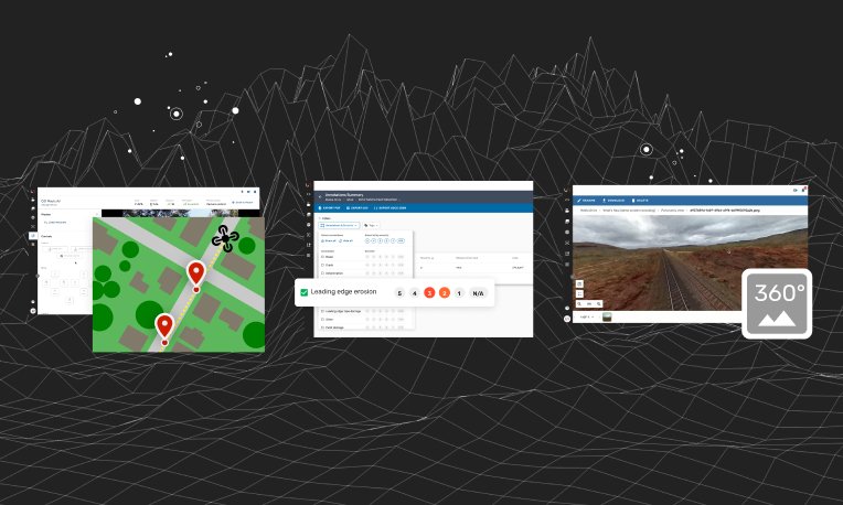
Automated missions from Geospatial data
Users can now pull asset information and generate work orders for automated drone missions from Geospatial data.
Integration with Esri and Digital Twin software also allows users to define specific automated inspection profiles per asset depending on its characteristics or inspection requirements. The final flight plan is then automatically pushed to the field crews for rapid, centralized, in field data collection. For jobs such as powerline corridor inspections, users are seeing 50% faster per pole inspection versus manual drone inspection.
Automated missions using pinpoint coordinates ensure consistency in image capture, meaning better comparison of asset conditions over time.

INTEGRATION
API for Flight Management Systems
We’ve made it easier for you to better manage UAV operation, compliance and risk.
After completing your Autofly drone mission, your flight logs and records will automatically be available in your secure cloud account for reporting and review purposes. This automation allows our customers to focus on key business activities while leaving tedious and repetitive data process to be run automatically in the background.
Keep an eye out for our soon to be announced native 3rd Party compliance software integration.

INTEGRATION
Download captured media via API
Reduce the time spent downloading and re-uploading across platforms. With our new API, you can now automatically download media into your system directly from Unleash live’s Media Library.

ADMINISTRATION
Teams and Permissions
Users now have the ability to create multiple teams in the Unleash live platform. Assign roles and toggle access to different features, data and files for better team management.
Explore past releases below

2023 Release #4
Access live feeds from all your devices (drone, CCTV, etc) in Fusion Atlas
Unleash Live partners with AstraUTM for enhanced drone management capabilities
Compare geographical layers side by side
Enhance your image viewing: Robust viewer with full metadata and tag support

2023 Release #3
Syncing Orthomap and KML layers
Support for DJI M3 and M30
Optimized flight planning with JSON and KML imports
2023 Release #2
Autofly marker drop on Atlas Fusion
Annotation summary and filter
Panoramic image viewer
-
Side by side image comparison slider
Rapid organization of power lines inspection images by asset geolocation
SafetyCulture’s iAuditor Inspections integration

Ready to get started?
See how Unleash live can help you automate workflows and reduce costs