


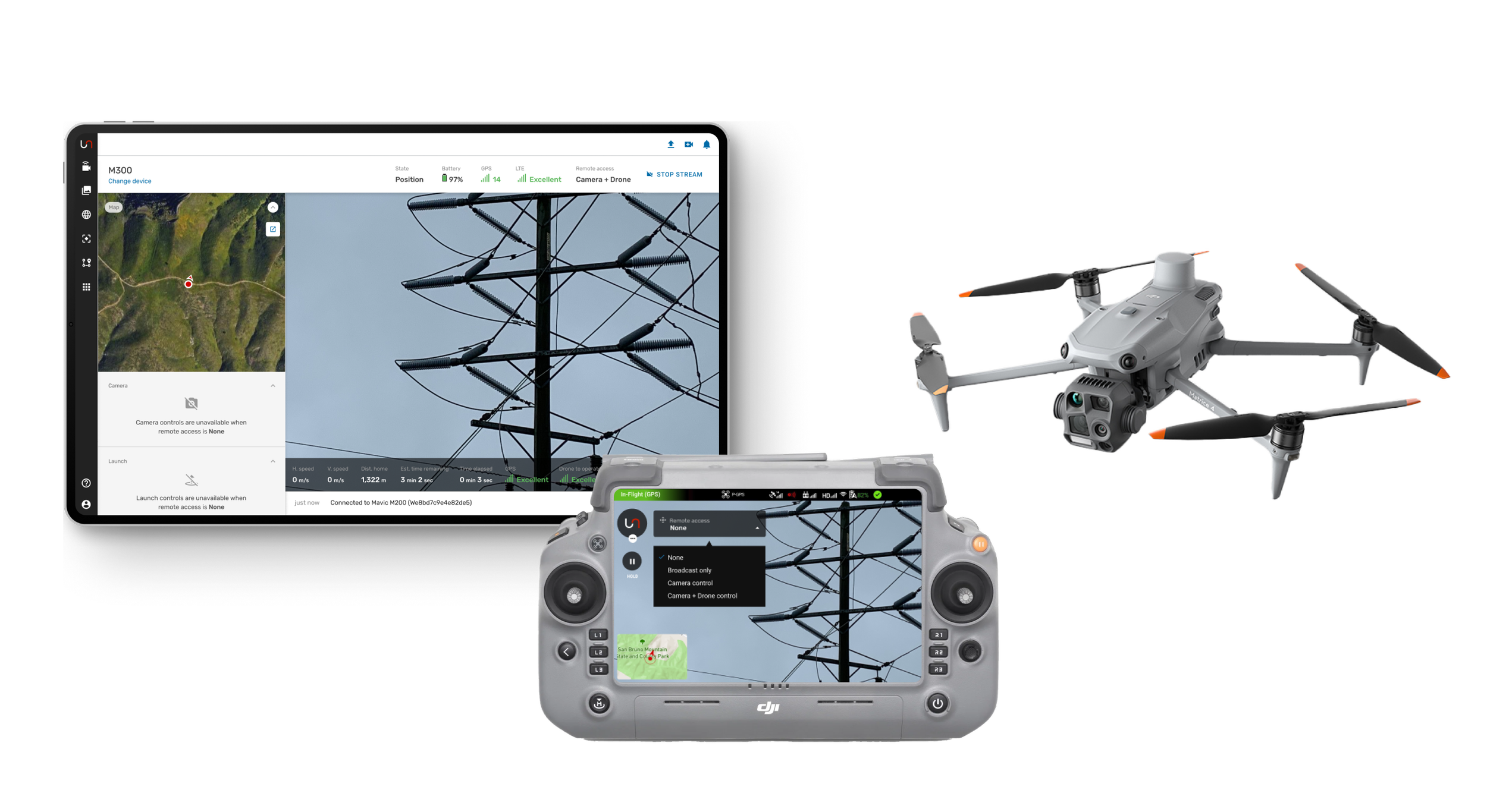
Experience remote operations with real-time control
Autofly app enables autonomous operations
Real-time operations
Plan, execute and document remote inspections
with your drone fleet
Superior collaboration
Bring remote stakeholders onto the live stream and hand over camera or flight control with confidence
An integrated platform
Move quickly from data to insights with Unleash live's powerful AI analysis, geospatial and modelling tools
Purpose built capabilities for your industry


Key features

ASSET CAPTURE
Automated precision data capture
Autofly streamlines the asset image capture process, supporting 3 types of missions (corridor, survey, individual assets), delivering:
Smart Inspect: automated missions for scanning assets with dedicated capture profiles
Consistent capture of high quality images
Reduction of repetitive tasks
Easy to compare change over time on asset
AI models for accurate fault detection

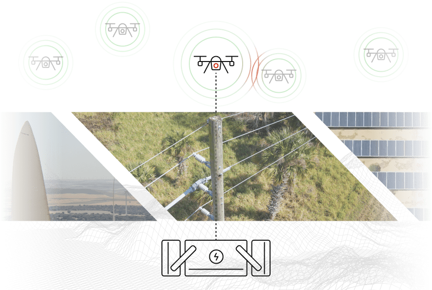
SITUATIONAL AWARENESS
Real-Time Collaboration
Enable seamless real-time collaboration between field pilots and operational centers offering:
Zero latency live streaming and two way push to talk audio
View, locate and track assets in real time with geospatial data
Distributed remote control of drone

DRONE OPERATIONS
Built by pilots, for pilots
A comprehensive solution for seamless and efficient flight management that includes:
Powering BVLOS flights with UTM integration for aircraft deconfliction and airspace management
Aircraft compliance with integrations for managing flight logs and resource management tools
Drone-in-box ready through integrations with Skycharge, DJI and other systems
ENGINEERS
Open architecture
A versatile and open architecture deployable on many connected vehicle types: robots, UAVs, drones, rovers and quadrobots. Built with modular components for operational fleet workflow:
Onboard apps: Precision Landing, Object Detection, Fault Detection
API connectors: Drone-in-Box, Media Sync, Flight logging
User Interface: 2-way communications, Mission Planning & Control, Stream sharing, Remote control

Integrated platform
Drone
Connect your drone to your controller as per usual. See our compatibility list for more details.
Autofly
Our Android app connects your phone or Smart Controller
to your Unleash live account
Unleash live
View and control* your fleet remotely, plan and execute missions, and store and share your media
*In accordance with local safety regulations. See our FAQ below for more information.


Security
Built on world leading infrastructure for secure and scalable deployment. Ensuring compliance with data sovereignty requirements.
We prioritise data security. Flight logs, data and missions in Autofly are not shared or synced with external parties.
Read more

CASE STUDY

Embry–Riddle Aeronautical University
Unleash live has been actively assisting Embry Riddle in the education and preparation of our future UAS operators.
Through the use of Autofly and the Unleash.Cloud platform, students are provided with a thorough exploration of diverse UAS applications that can be utilized in various sectors. This equips students for a wide range of career opportunities, including inspections, surveying, emergency response and more. With the utilization of Autofly, students gain valuable insights into mission planning, remote split operations, autonomous flight, unmanned traffic management (UTM), artificial intelligence and media management.
Diverse range of use cases
-
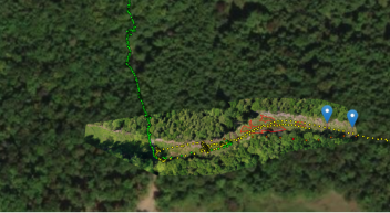
![Aerial view of a forested area with a winding trail marked with yellow and black dots, and two blue location markers at the trail's end.]()
Methane Leak Detection
RESOURCES
Unleash live build an automated drone inspection that captured video used for AI analysis. Our AI model and footage created a map of an entire methane plume from leak to extremity.
-
![Thermal image showing varying temperatures with purple, orange, and yellow colors indicating heat differences.]()
Blast monitoring
RESOURCES
Unleash live created an automated drone flight capturing images from the blast site radius. Images were analyzed in real time with AI model detecting people, ensuring safety and improving speed of access to the blast site.
-
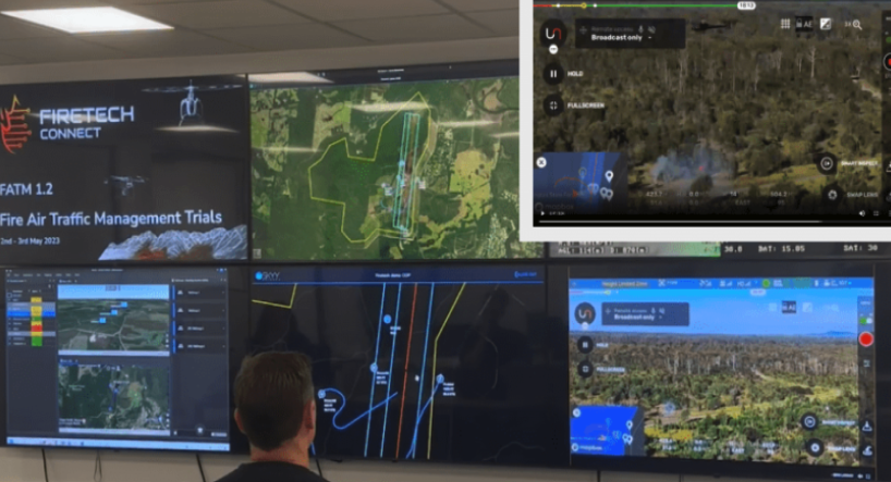
![Multiple screens displaying fire management data, maps, and drone footage, with a person observing in front of them.]()
Situational Awareness
EMERGENCY RESPONSE
Unleash live provides zero latency streaming and situational awareness solution that includes real time aircraft and asset positions and 2 way audio communication between command center and teams in the field.
-
![Three parallel railroad tracks on a gravel path with green grass on either side.]()
Automating Track Inspections
RESOURCES
Autofly and Track Component AI were used for a real time inspection of rail tracks. Drone inspection was 5x faster compared to standard technique. AI found faults and isolated specific areas of interest, showing cracks in rails, missing bolts or geometry misalignment.
-
![A volcanic crater emitting a smoke column in a barren landscape.]()
Environmental Protection Agency
RESOURCES
EPA increased operational efficiency of field inspections. Using Unleash live Live streaming, a single inspector was able to oversee several independent remote sites, greatly reducing operational cost.


Latest blog posts on Autofly
